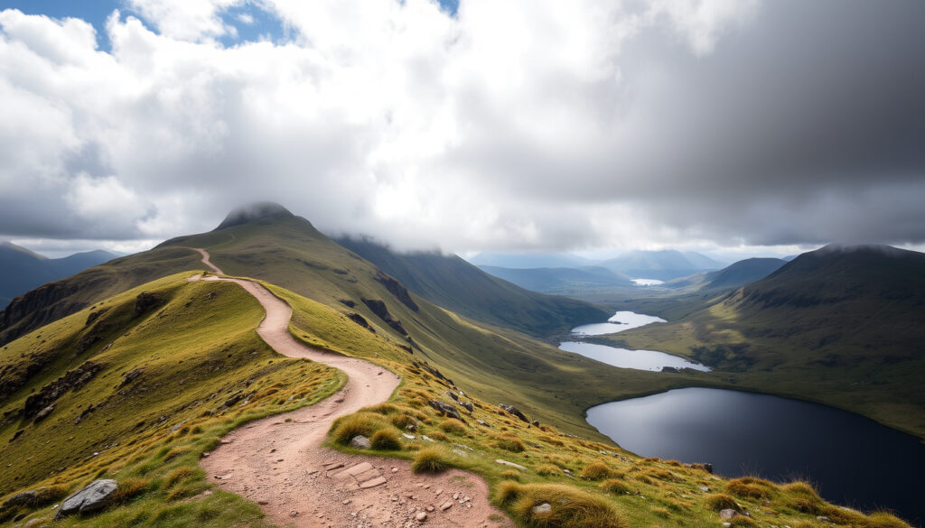
Cadair Idris Walk: Complete Guide to Routes & Difficulty
Few mountains in Snowdonia divide opinions quite like Cadair Idris — its 893 m summit stands lower than Snowdon, yet some walkers come down from the ridge convinced they’ve done the harder day. The answer is in the route data — official difficulty ratings, ascent figures, walking times and parking details — and it decides which path you should take.
Height: 893 m (2,930 ft) ·
Location: Southern Snowdonia, near Dolgellau, Wales ·
Walking time (ascent): 3–5 hours via popular paths ·
Difficulty grading: Moderate to strenuous (steep sections) ·
Best known for: Glacial corrie Llyn Cau and summit Penygadair
Quick snapshot
- Cadair Idris rises to 893 m (2,930 ft) (Wikipedia (reference encyclopedia))
- The Minffordd Path is officially described as “very strenuous” and demands a map, navigation skills and good fitness (Natural Resources Wales (national conservation body))
- The mountain sits within Eryri (Snowdonia) National Park (Eryri National Park Authority (park authority))
- The Minffordd/Dôl Idris car park postcode is listed as SY20 8AB in some guides and SY20 8AH in others — confirm before you set your satnav
- No official guidance settles which route is genuinely safest in ice or snow
- Peak-season parking capacity changes daily, with no live feed to check
- Minffordd Path: about 9 km return, 788 m of ascent, roughly 5 hours (Natural Resources Wales) (Visit Mid Wales (regional tourism board))
- Llanfihangel-y-Pennant: about 16 km (10 miles), roughly 7 hours (Visit Mid Wales (regional tourism board))
- Check the mountain forecast before leaving — this is not a hill where the valley weather holds (Met Office (UK national weather service))
- Carry a paper Ordnance Survey map even if you also use an app (Ordnance Survey (UK mapping agency))
- Review hill walking safety guidance before your first ascent (British Mountaineering Council (hill walking body))
- Get a second read on conditions from a national forecast service (BBC Weather (national forecast service))
Cadair Idris at a glance
Seven numbers, one portrait: a compact mountain whose presence is out of proportion to its height.
| Attribute | Value |
|---|---|
| Elevation (summit) | 893 m (2,930 ft) (Ordnance Survey (UK mapping agency)) |
| Prominence | 608 m (1,995 ft) (Wikipedia (reference encyclopedia)) |
| Location | Gwynedd, North Wales (Eryri National Park Authority (park authority)) |
| Grid reference | SH 711 130 (Ordnance Survey (UK mapping agency)) |
| First recorded ascent | Unknown, likely prehistoric |
| Mountain range | Snowdonia (southern edge) |
| Notable feature | Glacial corrie Llyn Cau |
Is Cadair Idris a difficult climb?
Is Cadair Idris harder than Snowdon?
Cadair Idris is lower than Snowdon, but the shortest official summit walk is graded “very strenuous”, and the main paths climb more than 700 m on the way up. Altitude is not the hard part; the gradient is.
The honest answer: yes for most people, but not because of height. At 893 m, the summit sits below the classic “big mountain” mark; what makes the day hard is the ground between the car park and the ridge. Natural Resources Wales describes the Minffordd summit walk as very strenuous and says it requires a map, navigation skills and good fitness.
The numbers explain the rating. The Pony Path gains about 727 m over roughly 10 km return (Visit Mid Wales (regional tourism board)); the Minffordd Path gains more, about 788 m, in a shorter 9 km. Squeeze that climbing into a day walk and the average gradient on the Pony Path sits near 15% — mountain terrain, not hill terrain.
What is the steepest section on Cadair Idris?
The steepest ground concentrates near the top. Both the Minffordd and the Pony Path finish on a rocky summit ridge, and the descent there is where tired legs collect the biggest falls.
On the Minffordd route, the steepest sustained work starts after Llyn Cau, where the path climbs the corrie wall toward the summit ridge (Wikipedia route notes (reference encyclopedia)). On the Pony Path, the final pull to Penygadair does the same job from the northern side. Either way, the summit is only halfway: the descent puts the same steep ground under tired legs.
How long does it take to walk up Cadair Idris?
What is the fastest route?
- Shortest route: Minffordd Path — about 9 km return
- Most popular route: Pony Path — about 10 km return
- Longest route: Llanfihangel-y-Pennant — about 16 km return
The fastest is the Minffordd Path, but “fastest” and “easiest” are not the same word. Natural Resources Wales budgets about five hours for that 9 km and 788 m of ascent; most walkers should add a buffer for photo stops, wind and wet rock.
How long is the Pony Path?
Pony Path distance: ~10 km (6 miles) return · Ascent: ~727 m · Typical walking time: 5–6 hours
Visit Wales (official tourism authority) estimates five to six hours for a return walk on most summit routes (Visit Wales (official tourism authority)), which makes the Pony Path a full-day commitment even though the summit is only 893 m. The long version, Llanfihangel-y-Pennant, runs about 16 km and typically takes around seven hours.
The implication: if you plan a 10 am start, you plan a late finish. Cadair Idris is a mountain that rewards early alarms.
Which is the easiest path up Cadair Idris?
What is the Pony Path in Cader Idris?
First-timers should treat the Pony Path as the default choice: it is the least technically difficult of the three routes, and its 727 m of ascent compares with 788 m on the Minffordd side. Hard doesn’t disappear — it becomes manageable.
The Pony Path starts at Tŷ Nant on the Dolgellau side of the mountain. Regional tourism body Visit Wales classifies all three principal routes — Minffordd, Pony Path and Llanfihangel-y-Pennant — as hard or strenuous, and still names the Pony Path as the least technically demanding (Visit Wales (official tourism authority)). That makes it the standard “first time on Cadair Idris” route for walkers with reasonable fitness.
Visit Wales’s guide makes the same point on the other side of the mountain: the Llanfihangel-y-Pennant route is the longest, but is often the easiest walking for much of its length. Visit Mid Wales calls the Pony Path a reasonably safe route with rewarding views, under normal mountain-walking conditions.
How does the Minffordd Path compare?
- Minffordd Path: about 9 km return, 788 m of ascent, official estimate 5 hours (Natural Resources Wales figures)
- Pony Path: about 10 km return, 727 m of ascent, typical estimate 5–6 hours
- Llanfihangel-y-Pennant: about 16 km return, commonly quoted at 7 hours
The Minffordd Path starts at Dôl Idris car park near Tal-y-llyn Lake (Natural Resources Wales) and is shorter. It is also steeper: fewer kilometres, more ascent, and a harder final push above Llyn Cau.
The trade-off: shorter routes demand more respect; the long route demands more time. Beginners get the best deal on the Pony Path; the Minffordd Path is for walkers who want lake views and a tougher workout.
Where to park to climb Cadair Idris?
What is the postcode for the Cadair Idris car park?
- Dolgellau side: Tŷ Nant / Dolgellau car park, postcode LL40 1DU — pay and display
- Minffordd side: Dôl Idris car park near Tal-y-llyn Lake, postcode listed as SY20 8AB or SY20 8AH depending on the guide — confirm before navigating
- Llanfihangel-y-Pennant: free parking near the church (Visit Mid Wales (regional tourism board))
There is no single “Cadair Idris” car park. The two main bases are the Dolgellau-side pay-and-display lot at LL40 1DU and the Dôl Idris car park at the foot of the Minffordd Path, where the postcode appears as both SY20 8AB and SY20 8AH. Both Dôl Idris and Tŷ Nant sit within the national park, where charges apply (Eryri National Park Authority (park authority)).
Is there free parking near the trailheads?
Free parking at Llanfihangel-y-Pennant is a real perk — until you add its extra kilometres to the day. Saving the fee can cost 6 km of extra walking before the climb even starts.
Yes, in one place: near the church at Llanfihangel-y-Pennant, the start of the longest route, parking is free. The paid lots at Dôl Idris and Tŷ Nant fill early on weekends and bank holidays, so arrive early or be ready to wait.
The practical rule: park where your route starts, not where the postcode is prettiest. The walk to the wrong car park can add an hour before the climbing begins.
What are some good walking routes around Cader Idris?
What is the most famous hike in Wales?
- Pony Path (from Tŷ Nant) — the classic gentle ascent
- Minffordd Path (from Dôl Idris) — the shorter, harder classic with Llyn Cau
- Llanfihangel-y-Pennant — the long, quiet approach through the valley
- Circular option — combine Pony and Minffordd over the summit ridge for a horseshoe day
The most famous hike in Wales is Snowdon, and few would argue otherwise. In the southern half of the national park, though, Cadair Idris is the name that comes up first — and the two routes that define it are the Pony Path and the Minffordd Path.
Are there circular walks around Cadair Idris?
A circular walk on Cadair Idris is not a shortcut — it’s a ridge traverse that links two hard routes. Budget for it like a full mountain day, not a casual loop.
Yes, if you link the Pony Path with the Minffordd Path over the summit. The Minffordd route passes Llyn Cau, the glacial corrie lake that gives the mountain its classic photograph, and climbs toward the summit ridge. Heading down the other side puts you at a different start point, so plan transport between the two car parks.
The point of a route guide is to match the mountain to the day you actually have. Cadair Idris rewards walkers who treat it as a mountain — not a viewpoint with a path on top.
Cadair Idris vs Snowdon: the honest comparison
Three routes, one pattern: every official line to the top of Cadair Idris is rated hard, which is why its modest height flatters no one.
| Feature | Pony Path | Minffordd Path | Llanfihangel-y-Pennant |
|---|---|---|---|
| Return distance | ~10 km (6 miles) | ~9 km | ~16 km (10 miles) |
| Total ascent | ~727 m | ~788 m | Not stated in official guides |
| Typical time | 5–6 hours | ~5 hours | ~7 hours |
| Official difficulty | Hard/strenuous — least technical | Very strenuous | Hard/strenuous |
| Parking | Tŷ Nant — paid, fills early | Dôl Idris — paid, fills early | Free near the church |
Figures are drawn from Natural Resources Wales, Visit Mid Wales and Visit Wales route guides, and they line up closely across all three. The honest read: Snowdon is the taller mountain, Cadair Idris is the one that makes you work for every metre it doesn’t have.
How to plan your Cadair Idris walk, step by step
A practical plan for a safe ascent
The biggest risk on Cadair Idris is not the climb — it’s the timetable. A late start with an afternoon weather change is the classic recipe for an epic you didn’t want.
- Pick your route by your fitness, not by the photo. First-timers: Pony Path. Experienced: Minffordd. Long-distance walkers: Llanfihangel.
- Check the weather twice — the night before and the morning of the walk (Met Office (UK national weather service)).
- Pack the non-negotiables: OS map, compass, headtorch, waterproof jacket and trousers, warm layers, food, water, power bank.
- Sort parking before you sort boots: paid lots at Tŷ Nant and Dôl Idris fill early; free parking at Llanfihangel-y-Pennant means a longer day.
- Start early enough that you are off the ridge by mid-afternoon, when mountain weather usually deteriorates.
- Tell someone your route and expected return time, and follow the British Mountaineering Council’s hill walking checklist (British Mountaineering Council (hill walking body)).
- If conditions look poor before the summit, turn around. The mountain will be there next month.
Treat the plan as a contract with yourself. If a step doesn’t fit — weather, parking, fitness — change the route or change the date.
What’s confirmed and what’s still unclear
The official sources used in this guide — Natural Resources Wales, Visit Wales, Visit Mid Wales, the Met Office, Ordnance Survey and the British Mountaineering Council — agree on a clear core of facts, and stay silent or diverge on a few practical details.
Confirmed
- Cadair Idris measures 893 m (2,930 ft) at the summit.
- The mountain lies within Eryri (Snowdonia) National Park.
- All three principal routes are described as hard or strenuous by the regional tourism authority.
- The Minffordd Path is described by Natural Resources Wales as very strenuous and unsuitable for walkers without navigation experience.
What’s unclear
- The exact postcode of the Dôl Idris car park: SY20 8AB in some guides, SY20 8AH in others — official pages don’t settle it consistently.
- Which route is safest in winter conditions: official grading doesn’t change with the seasons, but ice and snow alter the ranking.
- How busy the car parks will be on any given Saturday: no live capacity data exists.
- The full ascent figure for the Llanfihangel-y-Pennant route: official guides publish its distance and time but not a detailed elevation profile.
The gap between what we know and what we don’t is why this mountain deserves planning: the unknowns are all the kind that become problems at 600 m with cloud down.
Voices from the mountain
“One of the highest in southern Snowdonia … a popular peak to conquer.”
— Visit Wales, on why Cadair Idris belongs on walkers’ lists (Visit Wales (official tourism authority))
“The Minffordd summit walk is very strenuous and requires a map, navigation skills and good fitness.”
— Natural Resources Wales, on the route’s official grading (Natural Resources Wales (national conservation body))
Visit Mid Wales calls the Pony Path a reasonably safe route with rewarding views, under normal mountain-walking conditions.
— Visit Mid Wales, regional walking guide
Three organisations, one message: Cadair Idris is not a hill to wander up casually. The grading system exists because this mountain punishes complacency.
What this means for your walk
Cadair Idris is the mountain that asks for more than its height promises. The official guides are consistent — hard, strenuous, five to seven hours, weather that turns — and the walkers who struggle are the ones who read the summit height and nothing else. For first-time visitors to southern Snowdonia, the decision is clear: start with the Pony Path from the Dolgellau side, or let the Minffordd Path introduce you to a very long five hours.
Route data in this guide was drawn from Natural Resources Wales, Visit Wales and regional tourism sources in 2025. Always confirm current parking rules, access conditions and weather before you set out.
deepreport.uk, walkingenglishman.com, walesonline.co.uk, ukmountainsdirectory.co.uk
Frequently asked questions
Do I need a permit to climb Cadair Idris?
No. There is no permit requirement for walking Cadair Idris itself; the practical costs are parking charges at the trailheads.
What gear should I bring for a Cadair Idris hike?
Boots with good grip, waterproof jacket and trousers, warm layers, an Ordnance Survey map and compass, headtorch, food, water, and a power bank. Natural Resources Wales stresses a map, navigation skills and good fitness for the Minffordd route, and that standard applies to every route.
Can I climb Cadair Idris in winter?
Only with winter gear and experience. Ice and snow make the steep upper sections a different mountain. The Met Office forecast and daylight hours should decide your start time.
What is the best time of year to climb Cadair Idris?
Late spring to early autumn offers the longest daylight and the most stable conditions, but no season is safe on a mountain that makes its own weather. Check the forecast every time.
How many miles is the Cadair Idris walk?
It depends on the route: roughly 9 km (5.6 miles) on the Minffordd Path, 10 km (6 miles) on the Pony Path, and 16 km (10 miles) on the Llanfihangel-y-Pennant route.
Is Cadair Idris in Snowdonia National Park?
Yes. Cadair Idris sits in Eryri (Snowdonia) National Park, in Gwynedd, North Wales, on the southern edge of the park.
More related posts
 Match of the Day Presenters: New 2025 Hosts & Past Icons
 Oliver Tarvet: Biography, Wimbledon Qualifier & Ranking
 Julian Ovenden: Career, Family, and Latest Roles in 2024
 Patrick Bamford: Leeds Exit, Sheffield United, Salary & Net Worth
 Victoria Coren Mitchell Had a Baby at 51: Her Story
 Native Americans: Identity, Genetic Origins, and Common Myths
 Phoebe Gates: Activist, Founder, and AI Startup Scandal
 Stacey Solomon: Biography, Net Worth, Children, and Illness Facts
